Road Corridor Mobile LiDAR Survey for High-Voltage Feeder Design
Project Location: Huntingwood, NSW
Service: Mobile LiDAR Survey | 3D CAD Modelling | Digital Terrain Surface
Sector: Energy Infrastructure | High-Voltage Transmission
project gallery
Project Overview
Road & Civil Surveys was engaged to capture a 5-kilometre road corridor using mobile LiDAR scanning and produce a 3D CAD model and digital terrain surface to support the design and alignment of two new 132 kV high-voltage feeders connecting an existing substation to a new data centre facility.
Huntingwood, located within the Blacktown local government area approximately 30 kilometres west of the Sydney CBD, sits at the centre of one of Australia’s fastest-growing data centre precincts. Western Sydney’s combination of available industrial land, proximity to major motorway networks including the M4 and M7, and access to high-capacity electricity transmission infrastructure has made the area a primary location for hyperscale and enterprise data centre investment. Multiple facilities in the Huntingwood precinct are supplied via dedicated 132 kV sub-transmission feeders from the Endeavour Energy network, reflecting the significant power demands of modern data centre operations.
The routing and installation of new 132 kV feeders through established urban road corridors is a complex engineering task. Accurate spatial data of the existing road environment — including road geometry, kerb lines, drainage structures, utility infrastructure, signage, vegetation and clearances — is essential for the feeder alignment design and coordination with road authorities and other service providers.
The Road & Civil Solution
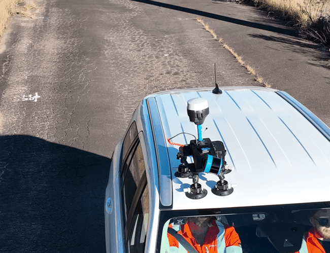
Road & Civil Surveys deployed its in-house Mobile LiDAR Scanning (MLS) system to capture the full 5-kilometre road corridor efficiently and safely within the live traffic environment.
- The MLS vehicle captured a high-density point cloud of the entire corridor, incorporating multiple camera systems for precisely georeferenced imagery alongside the LiDAR data.
- Multiple passes along the roadway were conducted to ensure complete coverage and maximise data accuracy through redundant scan overlap.
- Mobile LiDAR was the ideal methodology for this project — the survey was completed without road closures and without active traffic management, keeping people safe and minimising disruption to the busy Western Sydney road network.
- Fieldwork was completed in 2 days with a 2-person crew and the MLS survey vehicle.
- A full 3D CAD model and digital terrain surface were produced within 15–20 business days, providing the engineering design team with an accurate, feature-rich spatial dataset for the feeder alignment.
Key Outcomes
No Road Closures Required — Mobile LiDAR scanning captured the full 5 km corridor within live traffic conditions, eliminating the need for traffic management plans, road occupancy permits or lane closures on busy Western Sydney roads.
Rapid Fieldwork — The entire corridor was captured in just 2 days with a 2-person crew, compared to what would typically require significantly longer conventional survey programs for a corridor of this scale.
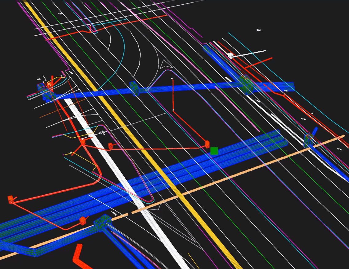
Accurate, Feature-Rich Deliverables — The combination of high-density LiDAR and georeferenced imagery produced a comprehensive 3D model capturing road geometry, utility infrastructure, drainage, vegetation, signage and clearances — all critical for 132 kV feeder route design.
Design-Ready Output — The 3D CAD model and digital terrain surface were delivered in formats compatible with engineering design software, enabling the design team to progress the feeder alignment without additional survey.
Project Snapshot
- 5 km Road Corridor Captured
- 2 Days Fieldwork
- 2-Person Crew
- 0 Road Closures Required
- 15–20 Days Model Delivery
Services Delivered
- Mobile LiDAR scanning (MLS)
- Georeferenced corridor imagery
- High-density point cloud capture and processing
- 3D CAD model production
- Digital terrain surface generation
- Feature extraction and classification
Why Mobile LiDAR for Corridor Surveys?
Road corridor surveys for utility design have traditionally required ground crews with total stations and GNSS equipment working within or adjacent to live traffic — a process that is slow, resource-intensive and carries inherent safety risks. Mobile LiDAR scanning transforms this workflow. By mounting high-speed laser scanners and precision camera systems on a survey vehicle, kilometres of corridor can be captured in a single pass at or near normal traffic speed.
The result is a dense, accurate and complete spatial dataset that captures not just the road surface, but every element within the corridor — kerbs, signs, poles, drainage pits, vegetation, overhead wires and existing underground utility markers. For high-voltage feeder design where precise clearances and alignment constraints are critical, mobile LiDAR provides the spatial confidence that conventional survey methods struggle to match at this scale.