Rail Surveying for Heavy Rail, Light Rail and Freight Corridors
Road & Civil Surveys provides construction and engineering survey for rail projects across New South Wales and Queensland: heavy rail duplications, light rail, freight corridors and the bridges, stations and systems that go with them. Our surveyors embed with the contractor’s team and work to the corridor’s access rules, so the survey keeps pace with a program that runs on possessions rather than daylight.
Rail Survey Services We Provide
Rail survey is construction survey with tighter tolerances, harder access and a stricter safety regime. The scope runs from corridor control before the first possession to the as-built track geometry at commissioning. We cover the whole sequence.
Corridor control networks. Establishing and maintaining primary and secondary control along the corridor, tied to project datum and the operator’s control where the project requires it, and re-observed through the job as earthworks and track work disturb marks.
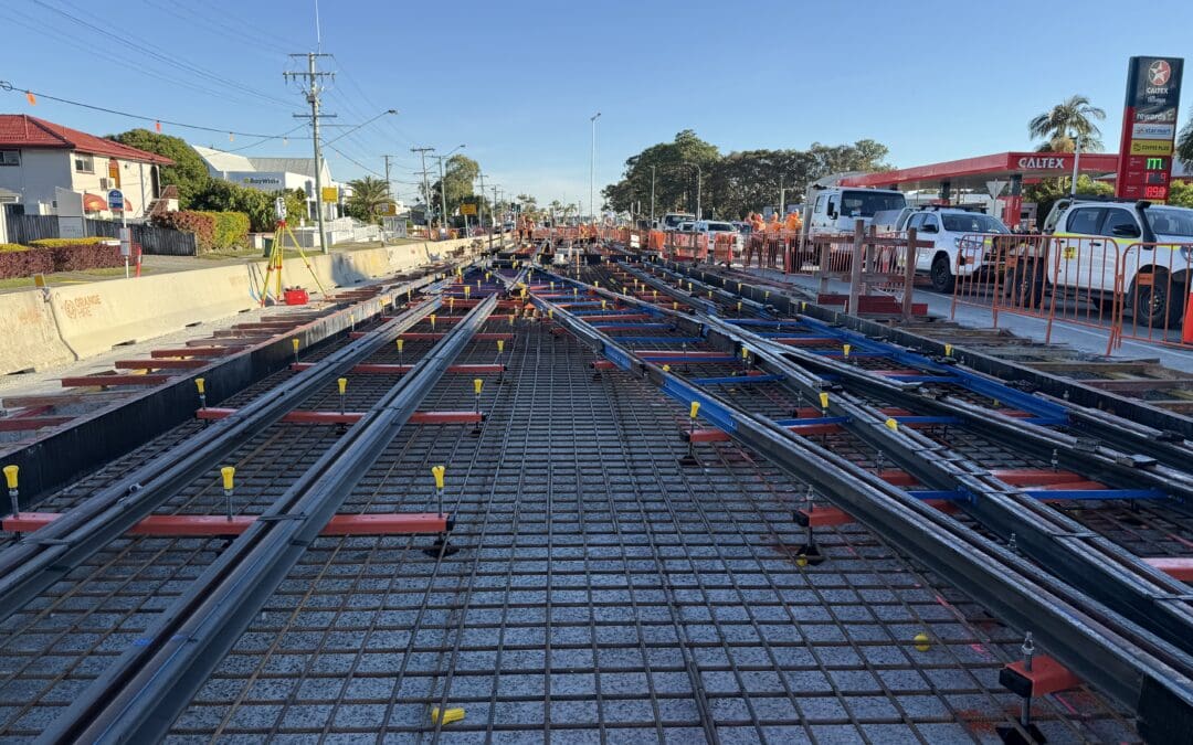
Track setout and alignment. Setout of horizontal and vertical alignment, cant and transitions for ballasted and slab track, sleeper and rail positions, turnouts and crossovers, and the formation and capping layers beneath.
Structures and overhead. Setout and conformance for rail bridges, underpasses, retaining walls, platforms and overhead wiring masts and gantries, where position and clearance to the rail are the whole job.
Track geometry and conformance. Measuring the installed track against design, recording as-built geometry and producing the conformance records the certifier and the operator need before trains run.
Corridor and clearance capture. Mobile LiDAR and UAV capture along the corridor for design, clearance checks and as-built records, gathered in far less track time than a conventional pickup.
Station and precinct works. Platform edges and coping, station structures, park and ride facilities, road overpasses and the civil works around a rail project, surveyed by the same crew that holds the corridor control.
How We Support a Rail Project
The survey scope shifts as a rail project moves from corridor to commissioning. We resource each stage for what it actually needs.
Corridor and early works
Existing track and corridor capture, service pickup, primary control and design validation before construction starts, so clashes are found on the screen rather than in a possession.
Civil and structures
Formation, drainage, bridges, culverts, retaining walls and platforms, set out and checked at each hold point while the corridor is still accessible.
Track and systems
Track alignment, slab and sleeper setout, rail positions, turnouts, overhead masts and signalling locations, worked to the possession program and checked before the next shift covers them.
Commissioning and handover
As-built track geometry, clearance records and the conformance package the operator needs, built through the project rather than assembled at the end.
Working in the Rail Corridor
Rail survey is shaped by access. The corridor is open when the operator says it is, often at night and often for a few hours, and everything the crew needs to do has to fit inside that window.
We plan survey around the possession program rather than the other way round. Control is set outside the corridor wherever it can be, so the crew walks in with the setup already done. Setout and conformance are prioritised by what the next shift needs, and anything that can be captured from outside the danger zone, by mobile LiDAR, UAV or long observations, is. That keeps time on track short and the possession productive.
Our surveyors work to the site’s rail safety requirements and the contractor’s protection arrangements as a matter of course. On a live corridor that is not optional, and it is a large part of why contractors ask for crews with rail experience rather than a general civil crew.
Recent Rail Projects
Rail survey work we have delivered across New South Wales and Queensland includes:
- Port Botany Rail Duplication: construction survey for John Holland and ARTC on the 2.9 kilometre duplication of the freight line between Mascot and Botany, including new bridges, crossovers and signalling, in a tight urban corridor beside Sydney Airport
- Parramatta Light Rail Stage 1: large scale construction survey for Parramatta Connect on 12 kilometres of new light rail, with more than 10 of our surveyors embedded at peak
- Gold Coast Light Rail Stage 3: specialist rail survey for John Holland on track installation along the 6.7 kilometre extension from Broadbeach South to Burleigh Heads
- Beerburrum to Nambour Rail Upgrade: construction and rail survey support for the Seymour Whyte and John Holland joint venture on the duplication and realignment of the North Coast Line, with new road overpasses replacing level crossings
- Railway Bridge Aerial Condition Assessment, Menangle: UAV inspection of the oldest metal railway bridge still in use in New South Wales
- Redbank Range Railway Tunnel Scan: 3D laser scanning of the first railway tunnel used by the NSW Railways, to inform a heritage condition assessment
Each of these ran with our surveyors working to the contractor’s program and the corridor’s access requirements.
Survey Control and Accuracy
Track tolerances are measured in millimetres and the geometry has to be right along the whole alignment, not just at the points you checked. Everything comes back to control.
We establish corridor control to project specification, tie it to the operator’s network where the project requires it, and re-observe it through the job. Setout is issued against a recorded design revision. Track geometry and structure conformance are picked up at each hold point and compared to design before the next stage covers them.
Data goes out in the format the project runs on: CAD and models for the design and digital engineering teams, conformance records for the certifier, and as-built geometry and clearance schedules for the operator’s asset system.
Put a Rail Survey Crew on Your Project
If you have a rail project starting, a possession program that survey needs to keep up with, or a corridor that needs capturing, talk to Road & Civil Surveys. We will look at the program, the access and the conformance requirements, then tell you what the project needs resourced. We operate from Gregory Hills in south west Sydney and Bundall on the Gold Coast, across New South Wales and Queensland. For road and civil work, see our road and civil construction surveying. For corridor capture, see our UAV, photogrammetry and LiDAR surveys, or our full range of survey services.